Khóa học
IELTS Online
IELTS Online
Giảm đến 18%
Đăng ký ngay
Mục lục [Ẩn]
Bài đọc “Growing more for less” mang đến góc nhìn thú vị về cách công nghệ vệ tinh đang thay đổi ngành nông nghiệp toàn cầu. Đây là chủ đề phổ biến trong IELTS Reading, đòi hỏi thí sinh không chỉ nắm vững kỹ năng đọc hiểu mà còn phải hiểu rõ các thuật ngữ chuyên ngành liên quan đến nông nghiệp, dữ liệu và công nghệ hiện đại. Hãy cùng Langmaster giải đề thi IELTS Reading: Growing more for less trong bài viết dưới đây
| Bạn đang ở band IELTS bao nhiêu? Làm bài test miễn phí và nhận ngay lộ trình học cá nhân hóa. 👉 Đăng ký test IELTS miễn phí ngay |
READING PASSAGE 2
You should spend about 20 minutes on Questions 14–26, which are based on Reading Passage 2 on pages 6 and 7.
Growing more for less
Satellite technology is helping farmers boost crop yields
A. For farmers, working out the optimal amount of seed, fertiliser, pesticide and water to scatter on a field can be a matter of luck, despite several harvests. Regular laboratory analyses of soil and plant samples from various sections of a field can help — but such expertise is costly, and often unavailable. However, a new and cheaper method of doing this analysis is now on offer. Precise prescriptions for growing crops can be obtained quickly, and less expensively, by calculating the amount of electromagnetic radiation reflected from agricultural land. The data is collected by orbiting satellites.
B. Examining the wavelength of radiation that is reflected can reveal, with surprising precision, the properties of the soil, the quality of crop being grown, and the levels in those crops of chlorophyll, various minerals, moisture and other indicators of their quality. If recent and forecast weather data is added, detailed maps can be produced indicating exactly how, where and when crops should be grown. The service usually costs less than US $15 per hectare for a handful of readings a year, and can increase yields by as much as 10%.
C. Such precision farming using satellite-based intelligence is a relatively new technique. Even so, it is catching on quickly. Five years ago, for example, a French cereal-growers' co-operative called Sevepi purchased a satellite and makes it available to its members in the form of maps of their fields, divided into three or four colour-coded zones per hectare. For each zone, the exact and best fertiliser formula is recommended. On top of this, if the amount of rain in the field has already grown quite high early in the season, and heavy showers are expected, an appropriate dose of growth regulator is recommended for each zone (as fragile stems break more easily in downpours). Then, farm vehicles equipped with global-positioning system locators automatically mix and apply the prescribed dose to each area.
D. France is the pioneer in this sort of surveillance. More farmland is analysed by satellite there than in any other country, according to Infoterra (a subsidiary of EADS Astrium), the firm that is France’s largest provider of such information, supplying data to companies such as Sevepi. Moreover, Henri Douche, head of Infoterra's agriculture sales in Toulouse, reckons the amount of monitored farmland will increase as weather patterns change and farmers can no longer rely on the past as a guide to the future. When confounded by the yield variations that these new weather patterns will bring, even farmers who are afraid of new technology will sign up, he says.
E. Inexpensive data on the productivity of land is advantageous to governments too. Areas where fertilisers and pesticides are being applied excessively can be pinpointed, enabling a reduction in environmental and land-use damage. Says Guy Lafond, an agronomist with Agriculture and Agri-Food Canada, a government agency, says the satellite data it purchases is proving useful for the study of fields with declining productivity in the province of Saskatchewan. Over-application of nitrate fertilisers (which are also a source of greenhouse gases) appears partly responsible. And according to RapidEye, a German satellite operator, some companies are also studying satellite data with a view to selling insurance policies to governments of famine-prone countries that might be threatened by crop failure.
F. In March, RapidEye began selling data that helps forecast harvests. "Too often, farmers limit productivity by managing fields wrongly," says Fredrick Jung-Rothenhäuser, head of product development at the firm's headquarters in Brandenburg an der Havel. "Our satellites are the first commercial satellites to include the Red-Edge band of the light spectrum, which is sensitive to changes in chlorophyll content. More research will be necessary to realise the full benefits of the Red-Edge band. However, this band can assist in monitoring vegetation health, improving species separation and also help in measuring protein and nitrogen content in biomass." The company's data, which comes from both Europe and the Americas, breaks field productivity down into patches just five metres square.
G. The advantages that satellite technology provides in terms of precision farming do not have to be restricted to rich countries. In Africa, where many areas have become badly depleted of nutrients, better fertiliser management would help reverse this situation. As a consequence, the charitable trust World Agroforestry Centre, in the city of Nairobi, in Kenya, has begun to build up a collection of radiation patterns derived from around 100,000 samples of African soils. The aim of this work is to help by understanding the potential of these soils to be more agriculturally productive. Once passed on to the International Centre for Tropical Agriculture, based in Colombia, South America, it is intended that the information be used to build a database called the 'Digital Soil Map'. When complete, this will provide farmers with free forecasts, developed with regularly updated satellite imagery, across farmland in the poorest countries in Africa. This is information which will almost certainly assist in improving crop yields. For a hunger-ravaged continent, that is good news indeed.

Questions 14–20
Reading Passage 2 has seven paragraphs, A–G.
Which paragraph contains the following information?
Write the correct letter, A–G, in boxes 14–20 on your answer sheet.
You may use any letter more than once.
Questions 21 and 22
Choose TWO letters, A–E.
Write the correct letters in boxes 21 and 22 on your answer sheet.
Which TWO companies obtain information directly from satellites?
Questions 23–26
Complete the sentences below.
Choose NO MORE THAN TWO WORDS from the passage for each answer.
Write your answers in boxes 23–26 on your answer sheet.
23. Initially, orbiting satellites are used to measure ............... coming from farmland.
24. Fredrick Jung-Rothenhäuser says that additional irregular weather will raise the ............... of satellite technology.
25. As a result of satellite technology, it may become possible to insure against the threat of ............... in some countries.
26. In Africa, much of the soil suffers from the loss of ............... .
>> Xem thêm:
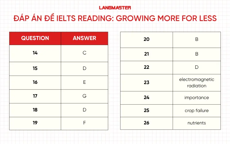
14. Đáp án: C
Thông tin đoạn C: “…a French cereal-growers' co-operative called Sevepi purchased a satellite … For each zone, the exact and best fertiliser formula is recommended.”
Giải thích: Đoạn C mô tả cách nông dân Pháp (thuộc hợp tác xã Sevepi) sử dụng dữ liệu vệ tinh để chia ruộng thành nhiều vùng nhỏ, từ đó xác định loại và lượng phân bón tối ưu cho từng khu vực. Đây chính là ví dụ điển hình về việc dùng dữ liệu vệ tinh để quyết định sử dụng phân bón.
15. Đáp án: D
Thông tin đoạn D: “Henri Douche… reckons the amount of monitored farmland will increase as weather patterns change and farmers can no longer rely on the past as a guide to the future.”
Giải thích: Câu này đề cập đến sự thay đổi thời tiết khiến nông dân không thể dựa vào kinh nghiệm cũ — đây là hậu quả trực tiếp của biến đổi khí hậu (climate change) ảnh hưởng đến canh tác.
16. Đáp án: E
Thông tin đoạn E: “…fields with declining productivity… Over-application of nitrate fertilisers (which are also a source of greenhouse gases) appears partly responsible.”
Giải thích: Đoạn E nói rõ việc bón quá nhiều phân đạm (nitrate fertilisers) dẫn đến suy giảm năng suất đất – tức là ảnh hưởng xấu đến chất lượng đất.
17. Đáp án: G
Thông tin đoạn G: “…World Agroforestry Centre… has begun to build up a collection of radiation patterns… Once passed on to the International Centre for Tropical Agriculture, based in Colombia…”
Giải thích: Đây là ví dụ về việc chia sẻ dữ liệu giữa các quốc gia – dữ liệu thu thập tại Kenya (châu Phi) được chuyển cho trung tâm ở Colombia (Nam Mỹ).
18. Đáp án: D
Thông tin đoạn D: “France is the pioneer in this sort of surveillance. More farmland is analysed by satellite there than in any other country.”
Giải thích: Đoạn D khẳng định Pháp là quốc gia đi đầu trong việc áp dụng công nghệ vệ tinh trong nông nghiệp — dẫn đầu thế giới về diện tích đất canh tác được phân tích bằng vệ tinh.
19. Đáp án: F
Thông tin đoạn F: “Our satellites are the first commercial satellites to include the Red-Edge band… More research will be necessary to realise the full benefits of the Red-Edge band.”
Giải thích: Đoạn F mô tả một công nghệ mới trong hình ảnh vệ tinh – dải “Red-Edge band”. Tuy nhiên, tác giả nói rõ rằng cần nghiên cứu thêm để tận dụng hết tiềm năng của nó.
20. Đáp án: B
Thông tin đoạn B: “The service usually costs less than US $15 per hectare… and can increase yields by as much as 10%.”
Giải thích; Chi phí thấp (dưới 15 USD/ha) nhưng năng suất có thể tăng tới 10% — đây là bằng chứng rõ ràng cho tính hiệu quả về chi phí (cost-effectiveness) của công nghệ vệ tinh trong nông nghiệp.
21-22. Đáp án: B & D
Giải thích
Đề bài: Which TWO companies obtain information directly from satellites? (Công ty nào trực tiếp thu thập thông tin từ vệ tinh?)
Thông tin đoạn D: “France’s largest provider of such information, supplying data to companies such as Sevepi, is Infoterra (a subsidiary of EADS Astrium).” => Infoterra là nhà cung cấp dữ liệu vệ tinh, tức là họ trực tiếp nhận và xử lý dữ liệu từ vệ tinh, sau đó bán lại cho các công ty như Sevepi.
Thông tin đoạn F: “In March, RapidEye began selling data that helps forecast harvests. ‘Our satellites are the first commercial satellites to include the Red-Edge band…’” => RapidEye sở hữu và vận hành vệ tinh thương mại của riêng mình, vì vậy họ thu thập dữ liệu trực tiếp từ vệ tinh.
Các lựa chọn khác không đúng:
23. Đáp án: electromagnetic radiation
Thông tin đoạn A: “Precise prescriptions for growing crops can be obtained quickly, and less expensively, by calculating the amount of electromagnetic radiation reflected from agricultural land.”
Giải thích: Ngay từ đầu, vệ tinh được dùng để đo lượng bức xạ điện từ phản xạ lại từ đất nông nghiệp – đây là cơ sở cho việc phân tích đất và cây trồng.
24. Đáp án: importance
Thông tin đoạn D: “Henri Douche … reckons the amount of monitored farmland will increase as weather patterns change … even farmers who are afraid of new technology will sign up.”
Giải thích: Khi thời tiết trở nên thất thường hơn, tầm quan trọng / nhu cầu sử dụng công nghệ vệ tinh sẽ tăng lên, vì nông dân cần công cụ chính xác để dự báo và điều chỉnh mùa vụ.
Lưu ý: Tên Fredrick Jung-Rothenhäuser xuất hiện ở đoạn F, nhưng câu hỏi này thực ra dựa trên nội dung đoạn D, nơi nói về weather patterns change và farmers will sign up more.
25. Đáp án: crop failure
Thông tin đoạn E: “...some companies are also studying satellite data with a view to selling insurance policies to governments of famine-prone countries that might be threatened by crop failure.”
Giải thích: Vệ tinh giúp dự đoán rủi ro mất mùa, từ đó các công ty có thể bán bảo hiểm chống lại crop failure (mất mùa).
26. Đáp án: nutrients
Thông tin đoạn G: “In Africa, where many areas have become badly depleted of nutrients, better fertiliser management would help reverse this situation.”
Giải thích: Câu này nói rõ rằng nhiều vùng đất ở châu Phi thiếu hụt chất dinh dưỡng, vì vậy từ cần điền là nutrients.
>> Xem thêm: Giải đề IELTS Reading: Robert Louis Stevenson (FULL ANSWER)
| Học mãi mà IELTS không lên band? Học thử IELTS miễn phí cùng giáo viên 7.5+, chấm chữa lỗi sai ngay lập tức. 👉 Đăng ký học thử miễn phí ngay |
Dưới đây là tổng hợp những từ vựng IELTS Reading và collocation quan trọng nhất xuất hiện trong bài đọc, kèm nghĩa giúp bạn hiểu hơn nội dung bài đọc:
Phần bài “Growing more for less” trong IELTS Reading mang đến thử thách điển hình của dạng bài đọc học thuật về công nghệ và nông nghiệp hiện đại. Bên cạnh khả năng đọc hiểu, thí sinh cần biết cách xác định từ khóa nhanh, tư duy logic và phân tích thông tin khoa học chính xác để tìm ra đáp án đúng. Đây là dạng bài rất hữu ích giúp bạn rèn luyện kỹ năng skimming – scanning – inference. Tuy nhiên, nếu chỉ luyện đề đơn lẻ mà thiếu chiến lược làm bài và hướng dẫn chuyên sâu, bạn sẽ dễ “mắc bẫy” ở các câu hỏi Matching hay Sentence Completion trong đề thi.
Để nâng cao band điểm IELTS Reading cũng như các kỹ năng khác, bạn cần một lộ trình học rõ ràng, và giáo viên hướng dẫn chi tiết. Đây cũng chính là điểm khác biệt của khóa học IELTS online tại Langmaster – nơi đồng hành cùng hàng nghìn học viên chinh phục mục tiêu IELTS thành công.

Qua bài “Growing more for less”, bạn không chỉ học được cách vận dụng công nghệ để cải thiện năng suất nông nghiệp, mà còn rèn luyện khả năng đọc hiểu các bài khoa học trong IELTS. Với sự đồng hành của Langmaster, việc “giải mã” Growing more for less IELTS Reading answers hay bất kỳ bài đọc học thuật khó nào khác sẽ trở nên dễ dàng, logic và đầy hứng thú hơn bao giờ hết.
![Giải đề thi European Heat Wave IELTS Reading [FULL ANSWER]](https://langmaster.edu.vn/storage/uploads/original/2025/11/20/european-heat-wave-ielts-reading-answers.png)
Tổng hợp đề thi European Heat Wave IELTS Reading Answers kèm phân tích chi tiết, từ vựng và đáp án giúp bạn tối ưu điểm Reading nhanh chóng.
![Giải đề IELTS Reading: The fashion industry [full answers]](https://langmaster.edu.vn/storage/images/2025/10/01/the-fashion-industry-ielts-reading-answers.webp)
Giải đề thi IELTS Reading “The fashion industry” kèm full đề thi thật, câu hỏi, đáp án, giải thích chi tiết, và từ vựng cần lưu ý khi làm bài.
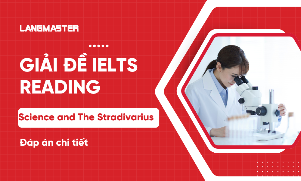
Bài viết tổng hợp đầy đủ đề thi IELTS Reading Science and The Stradivarius, đáp án kèm giải thích chi tiết, từ vựng cần lưu ý khi làm bài giúp bạn luyện thi hiệu quả và nâng cao band điểm.
![Giải đề IELTS Reading: Katherine Mansfield [Full answers]](https://langmaster.edu.vn/storage/images/2025/09/24/manh-anh-web-1.webp)
Giải đề IELTS Reading “Katherine Mansfield” kèm đáp án chi tiết, từ vựng quan trọng và bí quyết luyện thi hiệu quả để nâng cao band điểm.
Bài viết tổng hợp chi tiết đề thi IELTS Reading Holidays with a difference, đáp án kèm giải thích chi tiết, từ vựng cần lưu ý khi làm bài giúp bạn luyện thi hiệu quả và nâng cao band điểm.


Hơn 16 năm kinh nghiệm, đào tạo thành công hàng trăm nghìn học viên
Phương pháp giảng dạy hiện đại, học viên tiến bộ rõ rệt
Lộ trình học chuẩn quốc tế, phù hợp với nhu cầu thực tiễn
Giáo viên đạt chuẩn Quốc tế với chất lượng top đầu thị trường, giàu kinh nghiệm
Học online linh hoạt, cam kết đầu ra bằng văn bản